
GIS Projects
I wholeheartedly believe that GIS and spatial analysis will be one of the most powerful tools for understanding our world and making data-driven decisions in government, the private sector and for nonprofits in a diverse set of fields, albeit for security, climate change, disease management, product availability, service distribution, crime, education etc.

Health Site Distribution & Malaria Incidence
malaria & health site distrubution
For a comparative health course I took a preliminary look at the relationship between hospital distribution and child malaria incidence. I also considered bed net usage and compared these data between Tanzania and Kenya. It was an amateur look at spotty data, but it set into motion further interest on this topic.
During a GIS course the following year I decided to gather more recent and higher quality data to look at health site distribution and overall malaria incidence while considering topographic and climatic factors of rainfall, elevation, distance to water etc. I then used this data for policy memo assignments for a communications course.
Though I am still working on a robust spatial regression, I have presented the apparent correlation between health facility distribution and malaria incidence, which holds true when considering data over the past decade. I hope to conduct further impervious analysis and publish my findings. See working papers.
gis samples from labs
The below are samples of different techniques using the ArcGIS suite for an introductory GIS course.


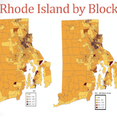
s4 summer 2015 gis institute
Through a partnership between Brown University Libraries, EarthLab, and the Population Studies and Training Center the S4 Institute offers student's a chance to get an introductory exposure to the beautiful world of spatial data and GIS. In 2015 I was a fellow in the institute and it has changed the direction of my academic and professional aspirations. The first project I ever worked on was an elementary attempt looking at migraine prevelence and hospital locale within Rhode Island.
I'm currently building a resource center for all things GIS and Geography related! Stay Tuned!